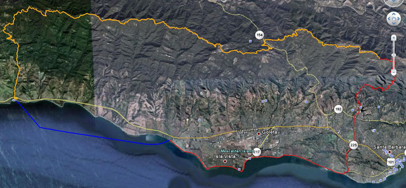
CLICK ON MAP FOR LARGER SIZE
|
Paddle (9 1/2 miles) BLUE
Starts at Refugio Beach between campsites 60 & 61 heading south pass El Capitan Beach, Naples Point around Haskell's Pier to the beach in front of the bathrooms/showers. |
Run (26 miles) RED
Starting from Haskell's Beach you'll head south along the beach, passing Devereaux Point, Campus Point and Goleta Beach (roughly 6 miles). Goleta Beach has bathrooms/showers and is a good place for an aid station. Continuing south on the beach you'll go through the "slough" (can be up to waist high) towards Hendry's Beach (6 +/- miles) which has bathrooms/showers/aid station. Continue running on Las Positas Rd. over the 101 freeway, State Street, across Foothill Road and just as you pass the water treatment plant on your left you'll come to the Jesusita Trailhead (4 +/- miles). For this next portion you'll want at least 72oz with you. It's about 3 1/2 miles up to Inspiration Point, 1 1/2 miles down to the start of Tunnel Trail (good place for a support member to hike to for an aid station) and about 4 miles to the top at East Camino Cielo. When you hit the pavement, head west (go left) for about a 1 1/2 miles and you'll reach the end of the run at the summit of La Cumbre Peak. |
Bike (38 miles) ORANGE
Starting at La Cumbre Peak you'll head west along East Camino Cielo towards 154. This section has a few modest uphills, but overall a long downhill of about 1800' in elevation in about 9 miles. Be extremely careful as you cross 154! Once you get to the other side of the 154 go left & take your immediate right which will be Kinevan Rd. This is a very narrow road and after 1 mile you'll hit West Camino Cielo. Turn right (sharp) and follow the road to the start of the dirt road at The Winchester Gun Club (4.7 miles & a good spot for an aid station). At the gun club is the start of the fire road, steep drop in the first mile, then mild but relentless uphill for 9 miles to Broadcast Peak. Total climb is around 2200'. Once you get to Broadcast Peak it's all downhill from here (15 miles) on paved road back to Refugio Beach between campsites 60 & 61 where the race finally ends! Now you get to enjoy a COLD BEVERAGE |
|

